Formerly Janakpur Engineering College (JEC)Affiliated to Tribhuvan University
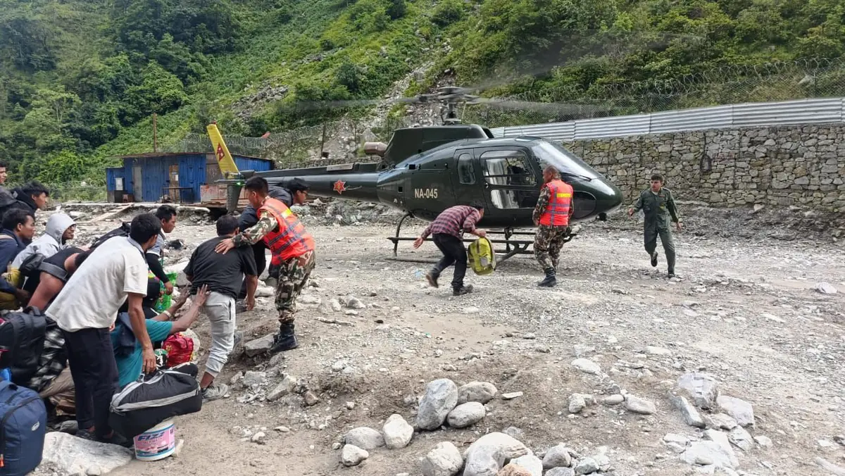
Villagers with bags carried toward a Nepali Army helicopter on a stony riverbank during the flood rescue
Public serviceEvery number sourcedNo sign-in

Emergency help in Nepal

icenepal.com · Imperial College of Engineering · Bhaktapur

नेपालीमा पढ्नुहोस् · प्रहरी १०० · एम्बुलेन्स १०२ · दमकल १०१ · ट्राफिक १०३

4 numbers that work with no balance7 provinces, with their police offices9 national desks and missions

Numbers checked 2 October 2026 · Figures from National Disaster Risk Reduction and Management Authority, 8 October 2026 · Roads as of 11 October 2026 · Cover photograph: Nepali Army, via The Rising Nepal.

The four numbers above are always open. Everything else is folded: open the one you need.

If you are in danger now, do not read this page. Call one of the four numbers below and tell them where you are.

These four reach an operator from any phone in Nepal, on any network, with no area code and no balance. They are the ones to use when you do not know who else to call. Say where you are before you say anything else, because a call that drops after you have given the location still gets someone moving.

Last checked by Imperial College of Engineering. Every number here was read off a Nepal Police, ministry, army or embassy page on that date. Numbers do change; if one fails, dial 100 and ask them to route you.

Call 100

Numbers checked 2 October 2026

If you are anywhere on the Budhi Gandaki below Chumnubri, or on the Trishuli near Benighat, stay on high ground and away from the riverbank. If you need help, call the Home Ministry on 1234 or the police on 100.

Two floods, two rivers: where the Gorkha flood isTwo floods, two rivers: where the Gorkha flood isAs of 1:20 pm, 11 October 2026. Schematic, not to scale. North is up.NBudhi GandakiSyar KholaTrishuliTrishuliPrithvi HighwayChumchetChumlingLokpaPhilimSirdibasSalleriJagatMachhakholaSotiArughatRasuwagadhiSyaphrubesiBetrawatiBidurKathmanduNaubiseGalchhiGajuriBenighatMuglin11. Began about 4 am4 herders missing at ChumchetCause not confirmed; a landslide dam is suspected22. 35 to 40 houses swept awayJagat, Salleri, Paiyun, Bagar; count still open33. Arughat gauge: 8.4 m at 8:40 amDanger level 5 m. No reading since.Arughat Bazaar was evacuated44. The warning reaches Trishuli DobhanNDRRMA 9:25 am: very high risk to Benighatand high risk as far as Muglin!Galaundi: Prithvi one wayRoad subsided 9 Oct; not this floodAs of 11 October 2026. Ring 103 first26 August floodBhote Koshi and Trishuli,Rasuwa and Nuwakot.A separate, earlier event11 Oct floodWarning reach26 Aug floodBridge lost (5)Two floods, two rivers: where the Gorkha flood isTwo floods, two rivers:where the Gorkha flood isAs of 1:20 pm, 11 October 2026Schematic, not to scale. North is up.Budhi GandakiTrishuli26 Aug floodPrithvi HighwayChumchetLokpaPhilimSirdibasSalleriJagatMachhakholaSotiArughatRasuwagadhiSyaphrubesiBetrawatiBidurKathmanduGajuriBenighatMuglin1234!1Began about 4 am at Chumchet4 herders missing; cause not confirmed235 to 40 houses swept awayJagat, Salleri, Paiyun, Bagar; count still open3Arughat gauge: 8.4 m at 8:40 amDanger level 5 m; no reading since4The warning reaches Trishuli Dobhan9:25 am: very high risk to Benighat, high to Muglin!Galaundi: Prithvi Highway one wayRoad subsided 9 Oct; not this flood. Ring 10326 August flood: Rasuwa and NuwakotA separate, earlier event on another river11 Oct floodWarning reachRoad: one wayBridge lost (5)
The Budhi Gandaki flood of 11 October and the August flood are on different rivers that meet at Trishuli Dobhan, near Benighat. The one-way stretch of the Prithvi Highway at Galaundi is a road collapse from August's erosion, not water from either flood.Imperial College of Engineering, from 1:20 pm, 11 October 2026 reports. Schematic, not to scale.

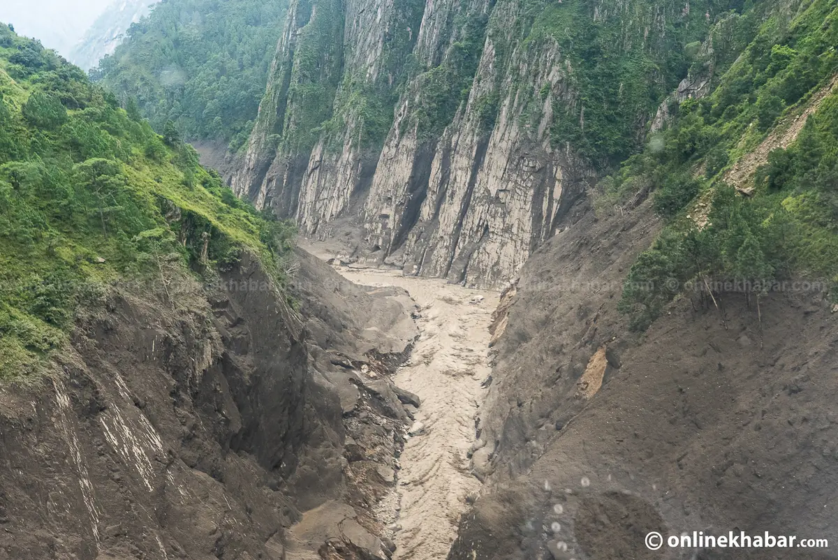
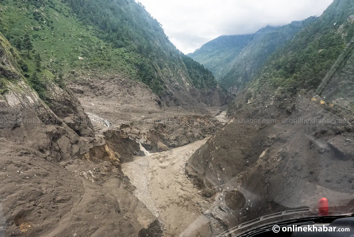
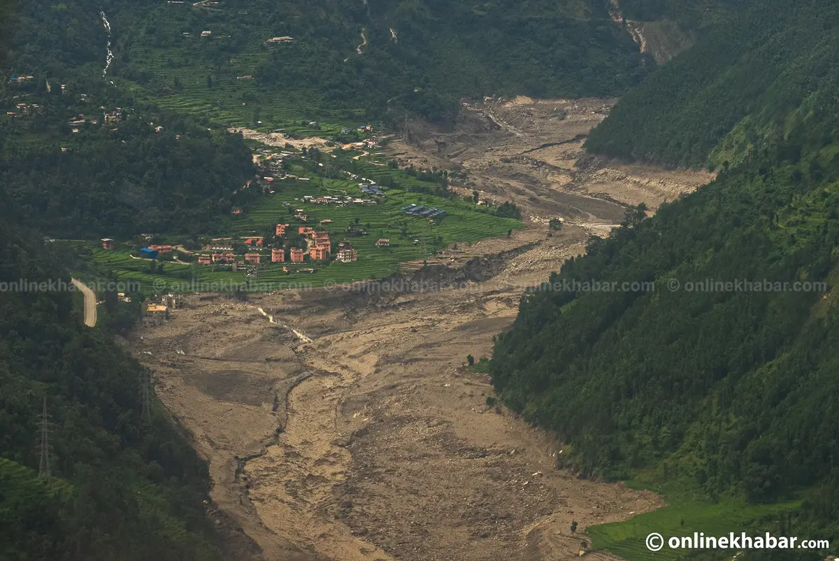
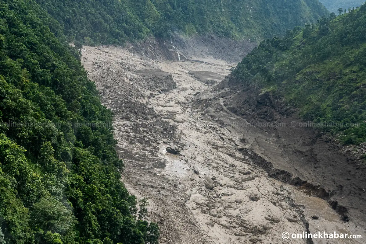
Villagers in upper Gorkha heard the rivers roaring at about 4 am on Sunday 11 October and ran for higher ground. At 6:40 am the Flood Forecasting Section of the Department of Hydrology and Meteorology warned everyone to keep away from the Budhi Gandaki as far down as Trishuli Dobhan, where it joins the Trishuli near Benighat. The department's gauge at Arughat crossed its 5-metre danger level at 7:50 am, and its last reading, at 8:40 am, was 8.4 metres. It had sent nothing since by 1:20 pm, 11 October 2026. We do not know why; a gauge can be damaged by the flood it is measuring.

No death had been confirmed by 1:20 pm, 11 October 2026. 4 herders who were staying in sheds by the Ungilung Khola at Chumchet were missing, and more herders on the way from Sirdibas to Chumling were out of contact; the Assistant CDO put those unaccounted for at at least 10. The Army airlifted 6 people from Jagat. The local administration estimated 35 to 40 houses swept away in Jagat Bagar, Salleri and Ghattikhola. The bridges reported lost are the motorable bridge at Soti linking Arughat wards 2 and 3, the bridge at Arughat between Gorkha and Dhading, the Nyakchet to Philim bridge on the Manaslu trail, the Nyakchet to Sirdibas suspension bridge and the Machhakhola to Kerauja suspension bridge. Police and local officials moved people out of Khorlabesi, Machhakhola, Soti, Arkhet and Arughat Bazaar, and the Home Minister said police, the Armed Police Force and helicopters had been sent.

Nobody official has said what caused it. Police and local officials point to a landslide that dammed a tributary, the Syar Khola or the Ungilung Khola, and then burst; residents said it had not rained. The department said the cause was still being studied and that the river could surge again, because it was reported blocked a second time at about 8 am. For the roads: at 9:25 am NDRRMA, citing the Flood Forecasting Division rated the Trishuli at very high risk as far as Benighat and at high risk as far as Muglin. That replaces the department's 8:55 am word that it saw no danger below Benighat. It is the stretch the Prithvi Highway follows, so please keep off the riverbank there and ring 103 before you travel. The roads section below has the highway's own state.

If your family is in Gorkha or Dhading and you cannot reach them, the Gandaki Province police are on 061-462500, and the missing-person section below has what to say. If you are one of our students and this touches your family, please call us on 01-5091616.

Sources: The Himalayan Times, 11 October 10:17 (NDRRMA 9:25 am); Kathmandu Post, 11 October 11:49; Kathmandu Post, 11 October 09:18; Kathmandu Post, 11 October 09:12; Kathmandu Post, 11 October 08:49; OnlineKhabar, 11 October; DHM via OnlineKhabar, 11 October 08:55; DHM river gauge via BIPAD.

National desks and disaster control

Directory · 4 desksThe disaster control room, the health emergency centre and the army, for when a settlement is cut off rather than one person.

Use these when a whole settlement is cut off rather than one person, when a district office is not answering, or when you need a decision that a local office cannot make. The toll-free numbers work from a phone with no credit on it.

  • Ministry of Home Affairs control room

    Toll free

    गृह मन्त्रालय नियन्त्रण कक्ष

    1112

    Also+977-1-4211208+977-1-4211214

    [email protected]

    The national disaster control room, toll free on 1112. This is the government desk that coordinates rescue across districts, and the right number when a whole settlement is cut off rather than one person.

  • Health Emergency Operation Centre

    Toll free

    स्वास्थ्य आपत्कालीन कार्य सञ्चालन केन्द्र

    1115

    Ministry of Health and Population, toll free. Health advice, where to take an injured person, and which hospital in an area is taking patients. The government has ordered free treatment for people injured in this flood — say so when you call.

  • Armed Police Force Headquarters, Halchok

    सशस्त्र प्रहरी बल

    1114

    The APF runs disaster rescue alongside the Army and the Police.

  • Nepali Army — Directorate of Disaster Management

    नेपाली सेना, विपद् व्यवस्थापन निर्देशनालय

    +977-9863028539

    Also01-5979364

    [email protected]

    The mobile is the duty officer, staffed around the clock. The Army is flying the helicopter rescue in Rasuwa and Nuwakot; this is the directorate that tasks it.

Call 1112

Numbers checked 2 October 2026

Where to call in your province

Directory · all 7 provincesEvery province police office, the districts it covers, and a link to that province's own list.

Each province police office below is the one that coordinates the district offices under it. The link on every card opens that province’s own Nepal Police helpline page, which lists its district offices. Those numbers are mostly personal mobiles that move with the officer, so we send you to the source rather than serve you a copy that has quietly gone stale. Police control on 100 reaches all of them.

Kathmandu Valley district offices

Listed separately because the college is in Bhaktapur and most people reading this page are either in the Valley or trying to reach it. These are the three district police offices, published by Nepal Police for Bagmati Province.

Call 100

Numbers checked 2 October 2026

Helplines for a particular situation

Directory · 4 desksWomen, children, tourists, blood, and the government's own grievance line.

A disaster does not fall on everyone the same way. These desks exist because the person who needs them is usually not the person who needs disaster control, and in a relief camp they are frequently the first number that should have been called.

  • National Women Commission — Khabar Garau

    Toll free

    खबर गरौँ

    1145

    Also01-425670101-4250246

    Toll free, 24 hours, for women and girls: violence, trafficking, an unsafe shelter, or being separated from a family in a relief camp.

  • Child Helpline Nepal (CWIN)

    Toll free

    बाल हेल्पलाइन

    1098

    Toll free, for a child who is missing, unaccompanied, or at risk.

  • Tourist Police

    पर्यटक प्रहरी

    1144

    Also01-4247041+977-9851289444

    For foreign visitors, and for Nepali families whose relative was trekking or driving in the affected corridor.

  • Hello Sarkar

    Toll free

    हेलो सरकार

    1111

    The Prime Minister's Office grievance line. Not a rescue number — the one to use when a government office is refusing to act and you need that on record.

Numbers checked 2 October 2026

Calling from outside Nepal

Directory · missions abroadThe short codes do not work from abroad. These are the missions being given the recovery lists.

The short codes above are reachable only from inside the country. From abroad, dial the full numbers with the +977 country code, or use the mission numbers below. A large share of the people unaccounted for on this river are foreign nationals, and their embassies are being given the recovery lists directly.

If your country has no mission listed here, contact your own foreign ministry and ask them to raise it with their mission in Kathmandu, and give the same details to the Tourist Police on 1144. Nepal’s tourism board is keeping a separate register of missing visitors and it is fed from those two routes.

Call 1144

Numbers checked 2 October 2026

If you are looking for someone

What to do · district policeWhich office takes the report, and the five things the officer will ask you for.

Step by step, including how to give a DNA sample: how to report a missing person after the Rasuwa flood.

Missing-person reports for this disaster are taken at district police offices, and they are collated centrally from there. Go to the district office where the person was last known to be, not the one where you live, because that is the office holding the recovery records for that stretch of river. If you cannot travel, call the province office in the list above and ask them to take it by phone.

Have these ready before you call, because the officer will ask for all of them:

  • Full name as written on the citizenship or passport, and age.
  • The last place they were known to be, and the last time anyone spoke to them.
  • What they were wearing, and any vehicle, plate number or bus they were travelling on.
  • A recent photograph, and any identifying mark.
  • Your own number, and a second number that will be answered if yours cannot be.

Give the same details to the Nepal Police control line on 100 as well. The two records are kept separately and a name in only one of them is a name that can be missed.

Call 100

Numbers checked 2 October 2026

Relief for families, and what changed on 30 September

Relief · 30 September 2026The state's relief amounts, the route for families of the missing, and the move to search and recovery.

On 30 September 2026 the National Disaster Risk Reduction and Management Authority’s executive committee, chaired by Home Minister Sudhan Gurung, decided to move the government’s effort from rescue to search and recovery, because the chance of finding survivors has faded (Radio Nepal). On 5 October 2026 the National Council for Disaster Risk Reduction and Management, chaired by the Prime Minister, suspended the search and rescue phase for the time being and kept only urgent operations (OnlineKhabar).

For families of the missing, it approved a special administrative route so that relief does not wait for the 12-year legal declaration of death. The local government certifies the information, the District Administration Office certifies it again, and the authority then provides the relief. It is a route to relief and not a declaration of death.

The authority’s chief, Dharmaraj Upreti, said the state pays Rs 200,000 when one member of a family dies and Rs 100,000 for each further person, that this is immediate relief and not final compensation, that families whose houses were destroyed will get a separate package, and that a self-declaration that a relative is missing will be accepted (Kathmandu Post, 29 September). We have not found a published application form or portal, so please ask your ward office and the District Administration Office which papers they want.

3,685 DNA samples were being tested, 1,957 at the Nepal Police laboratory and 1,728 at the National Forensic Laboratory, and 112 bodies had been identified. How to give a sample is on the missing-person page.

Relief rules as of 30 September 2026

How to help, and the rule most people are breaking

One-door policy · money and goodsPrivate collections are illegal right now. Where the money goes instead, and the three collection points.

Relief for this disaster is being run under a one-door policy. Private organisations, groups and individuals may not independently collect money or materials for it, and unauthorised collections are illegal, including the ones being organised on social media right now. The reason is not bureaucratic: uncoordinated collections in past disasters put lorries of the wrong goods on the only open road while the right ones waited behind them.

So the college is not opening a fund and is not taking collections, and neither should you. Money goes to the Prime Minister's Disaster Relief Fund:

Goods, rather than money, go to one of three collection points. Call the focal person before you load anything, and ask what is actually needed that day. The answer changes, and the wrong pallet occupies a road.

  • Relief arriving from outside Nepal

    National Emergency Operation Centre warehouse, Tribhuvan International Airport

    +977-9841879222

    Shraddha Bhattarai

  • Relief for Nuwakot

    Nepali Army, Maithali Barracks, Battar

    +977-9851234324

    Aabishkar

  • Relief for Dhading

    Nepali Army, Baireni Barracks

    +977-9851154226

    Dilip Ghale

Blood is the one thing an individual can give directly and immediately. Ask the blood bank at your nearest hospital, or ring the Health Emergency Operation Centre on 1115, toll free, and ask where it is short.

Numbers checked 2 October 2026

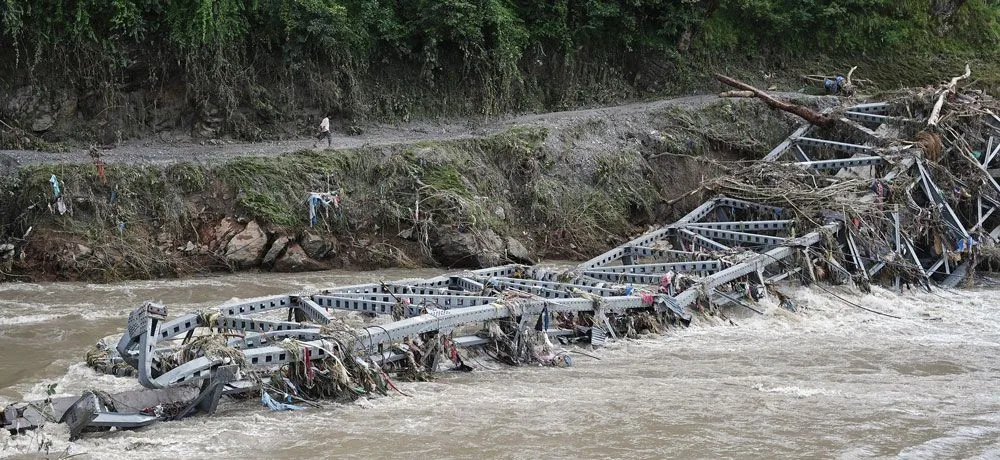
A steel truss bridge folded into a brown flooded river, with a man walking the road on the far bank

Roads, and whether you can travel

Travel · checked 11 October 2026Which routes are severed, which bridges are gone, and what to check before you set out.

The same list, on its own page with the date and time of the last check: Prithvi Highway and road status.

By the count of 30 September 2026, the flood destroyed 33 motorable bridges and 69 kilometres of road between Rasuwagadhi and Malekhu. Where a bridge is gone, a helicopter is currently the only way in and out. Check 103 before you set out, not after. This is what was where each road stood as of 11 October 2026:

  • Prithvi Highway

    One way at Galaundi near Gajuri, where the road subsided on 9 October; the Department of Roads planned two-way traffic from 6 pm on 11 October

    At about 5 pm on 9 October the road subsided at Galaundi, Gajuri-5, Dhading, on the Kathmandu side of Gajuri. Nearly 100 metres cracked and 20 metres collapsed, and the Department of Roads blames the Trishuli cutting under the road since the 26 August flood. Nepal Police listed it fully blocked on the morning of 10 October. Crews cut about 160 metres into the hillside, and the Department of Roads said it would run traffic one way from 9 pm on 10 October, widen the road from 7 am on 11 October with short stops, and open both directions by 6 pm on 11 October if the weather held. By 9:45 am on 11 October we had found no report that two-way traffic had started. The Department asked people not to travel unless they have to. Krishnabhir, Chalise and the other slopes named after the September rain are still the weak points. This is the road anyone coming from Pokhara, Chitwan or Butwal travels on, so please ring Traffic Police on 103 on the morning you set out, and expect queues in Dashain.

    Sources: Kathmandu Post, 10 October; Nepal Police list via DC Nepal, 10 October; Department of Roads via Ratopati, 10 October; OnlineKhabar, 10 October.

  • Kanti Lokpath (Kathmandu to Hetauda)

    Carrying the small vehicles turned away from the Prithvi on 10 October; not on the police list of that morning

    Nepalnews reported a landslide blocking the Kanti road at Takurche, Bagmati Rural Municipality-3, Lalitpur, on 2 October. On the evening of 10 October the Kathmandu Post reported small vehicles being sent along the Kanti road and the Tribhuvan Rajpath while the Prithvi was shut, and Nepalnews reported it so busy that vehicles were held at the New Bus Park in Gongabu. It is not on Nepal Police’s list of obstructed roads of 10 October. Expect it to be slow. The Balkhu, Kulekhani, Bhimphedi and Hetauda road was reported open by the Department of Roads on 29 September and we have found nothing newer.

    Sources: Kathmandu Post, 10 October; Nepalnews, 10 October; Nepal Police list via DC Nepal, 10 October.

  • Mahendra Highway (Chitwan section)

    No report on the Chitwan section after the closure of 26 September; not on the police lists of 7, 8 and 10 October

    The Chitwan administration stopped travel on the Mahendra and Prithvi highways on 26 September (Kathmandu Post). We have not found a report that the Chitwan order was lifted, and the Chitwan section is not on Nepal Police’s lists of obstructed roads of 7, 8 and 10 October. West of Narayangadh, the old iron span of the Lokaha bridge between Pragatinagar and Kawasoti sagged on the evening of 10 October, and the Bharatpur road office said traffic was running normally on the new bridge beside it (OnlineKhabar). The 8 October police list named a section much further west, one way at Chorkhola and Bankasbas in Shivaraj Municipality-1. Ask 103 before you set out.

    Sources: Kathmandu Post, 26 September; Nepal Police list via DC Nepal, 10 October; OnlineKhabar, 10 October.

  • BP Highway (Kavrepalanchok)

    Blocked by a mudflow at Pinthali on the morning of 10 October and reported reopened later that day, in one report that gives no hour

    The flooded Roshi blocked the Bhakundebesi to Mangaltar section at eight places and stopped traffic for five days. Vehicles began using a permanent track still under construction at around 10 am on 29 September, and the Kathmandu Post reported on 1 October that two-way traffic had resumed that Tuesday. On the morning of 10 October Nepal Police listed it fully blocked again, by mud and flood water at Pinthali, Roshi Rural Municipality-9, Kavrepalanchok. A news item reposted that day said it had reopened, without an hour or whether both directions run. It has now closed twice in two weeks. This is the road into the Valley from the east and from Sindhuli, so please ring 103 before you take it.

    Sources: Nepal Police list via DC Nepal, 10 October; newsofnepal via Hamro Patro, 10 October; Kathmandu Post, 1 October; Kathmandu Post, 29 September.

  • Tribhuvan Highway

    One way at Khatripauwa, Dhunibesi-9 (police, 8 and 10 October); the Makwanpur stretch runs one direction at a time in set hours

    Nepal Police’s list of obstructed roads published on the morning of 8 October says the Tribhuvan Rajpath runs one way only at Khatripauwa, Dhunibesi Municipality-9, after a landslide. It gives no hour. On 25 September the traffic police had reported one-way traffic near Nagdhunga and Pataleban (OnlineKhabar); the 8 October list does not mention those places. The list of 10 October still has it one way there. Further south, the Makwanpur administration set the hours (Ratopati, 10 October): on 11 October Hetauda to Kathmandu from 4 to 10 am and Kathmandu to Hetauda from 2 to 7 pm, passenger vehicles up to 11 metres only. Ratopati reported more than a hundred buses held for up to 36 hours between Palung and Hetauda. This is the western entry into the Kathmandu Valley, so allow extra time if you come in from Naubise or the Prithvi Highway.

    Sources: Nepal Police list via DC Nepal, 10 October; Ratopati, 10 October; Nepal Police list via DC Nepal, 8 October; OnlineKhabar, 25 September.

  • Rasuwa highways (Trishuli to Rasuwagadhi)

    Fully blocked (police, 7 and 10 October); a Bailey bridge at Betrawati was about half installed on 8 October

    Nepal Police’s list of 7 October says every main highway in Rasuwa stays fully blocked until further notice, and the list of 10 October still has them fully blocked. A track cut by the Nepali Army and the Department of Roads reached Betrawati on 30 September (Ratopati). eAarthik reported on 8 October that about half of the Bailey bridge there was installed and that the authorities plan to run Nuwakot to Rasuwa traffic over it within the coming Sunday; that is a plan, not an opening. A 76-metre Bailey bridge is planned at Syaphrubesi. The Friendship Bridge at Rasuwagadhi went in the flood and Kerung stays closed. Across the whole reach, 69 kilometres of road and 33 of 37 affected motorable bridges were destroyed (NDRRMA, to 3 October).

    Sources: Nepal Police list via DC Nepal, 10 October; Nepal Police list via Ratopati, 7 October; eAarthik, 8 October; Ratopati, 30 September.

  • Araniko Highway and the Tatopani crossing

    The Nepali road has reopened, the minister said on 6 October; China keeps the Tatopani crossing suspended

    Infrastructure Development Minister Sunil Lamsal told a parliamentary committee on Tuesday 6 October that the road on the Nepal side had already been reopened, and that the Chinese side did not yet appear ready to resume operations at Tatopani (PTI). On 30 September the Charikot road office had said the Nepali side ran one way during the monsoon. Anything going north through Tatopani should be treated as stopped.

    Sources: PTI via ThePrint, 7 October; OnlineKhabar, 30 September.

A steel truss bridge folded into a brown flooded river, with a man walking the road on the far bank
One of the 41 bridges. Where a crossing went, a helicopter is currently the only way in or out of the settlement behind it.Sujan Gurung, The Rising Nepal.
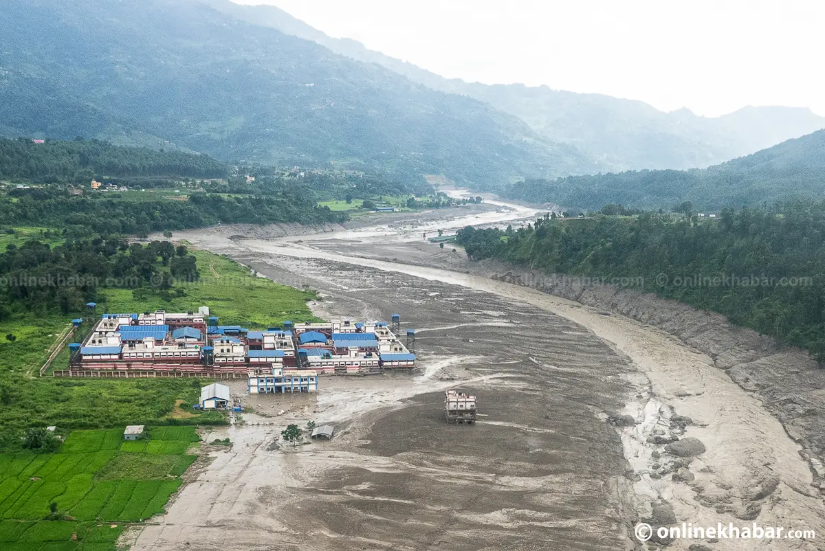
Aerial view of a riverside town with a helicopter overhead beside a river channel widened by the flood
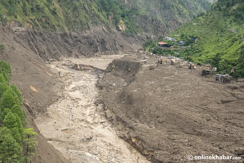
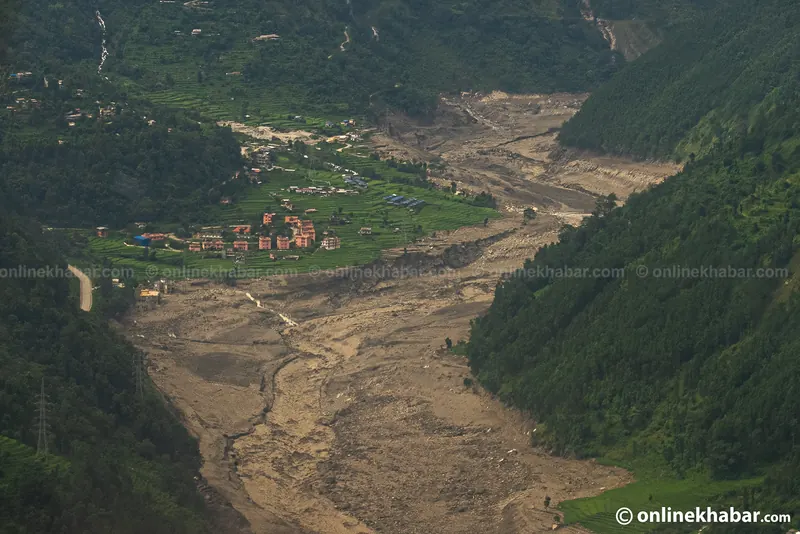
A town on the new edge. Every settlement along this river is now beside a channel a different width from the one it was built next to.Kamal Prasai and Dinesh Gautam, Onlinekhabar.

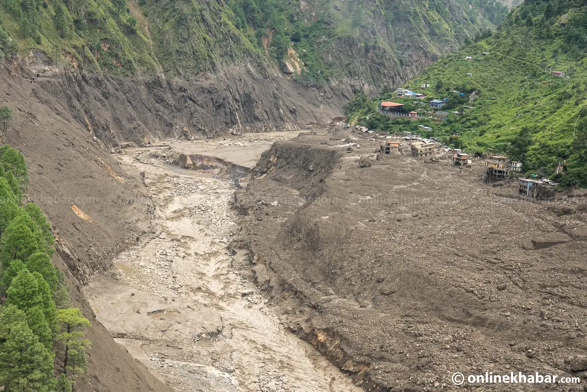
Every settlement on this river is now next to a channel a different width from the one it was built beside, and stretches of the valley floor are carrying an estimated ten to eighteen metres of new sediment. Rebuilding here starts with deciding what that ground is now, which is a survey problem before it is a construction one.

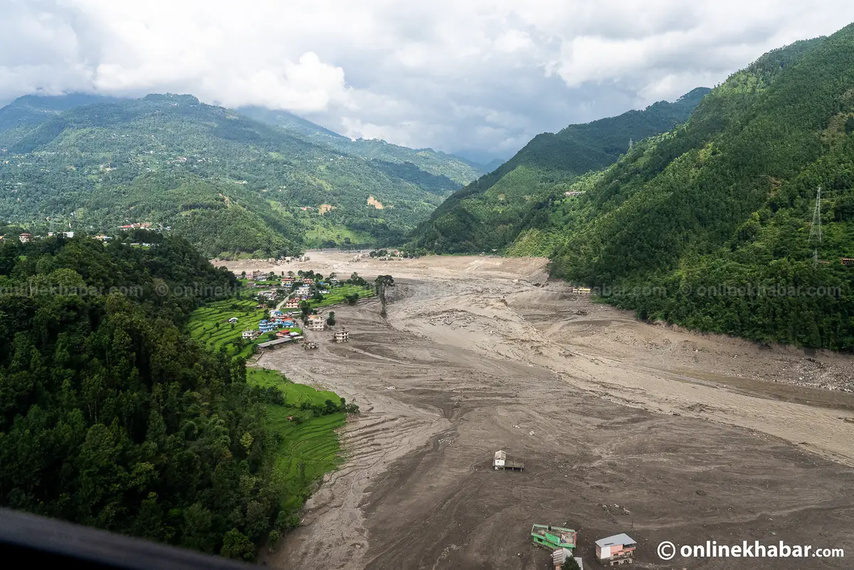
Aerial view of a settlement sitting at the edge of a wide new grey plain of flood deposits
Ten to eighteen metres of new sediment is the published estimate for stretches of this valley floor. Rebuilding here means deciding what that ground is now.Kamal Prasai and Dinesh Gautam, Onlinekhabar.
Call 103

Roads as of 11 October 2026

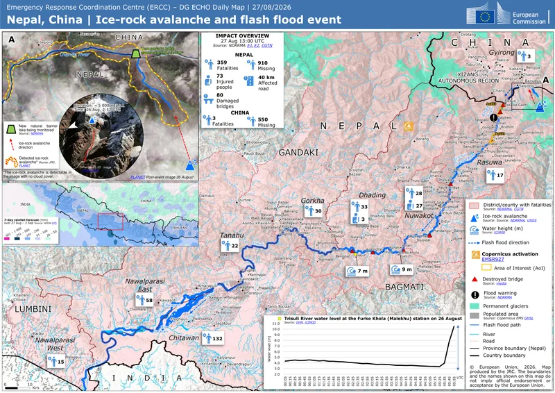
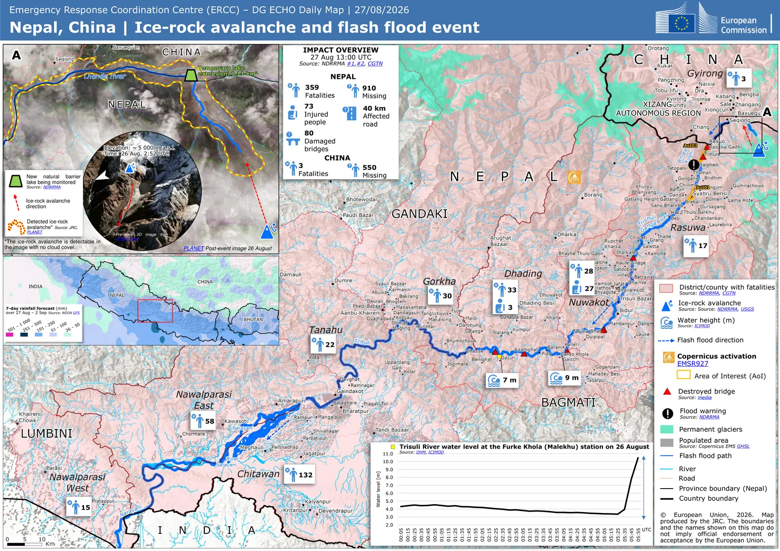
European Commission map of the ice-rock avalanche, the flood path down the Trishuli, and deaths by district

What happened on the Trishuli

The flood · figures of 8 October 2026A glacier collapse on the border, no monsoon behind it, and the count as it stands.

On the morning of 26 August 2026 (10 Bhadra 2083), shortly after 8:30 in the morning, an ice-and-rock avalanche from the north face of Langtang Lirung, on the Nepali side of the border, which fell about 1,200 metres into the Lhende Khola, the stream that marks the border, and ran on into the Bhote Koshi and then the Trishuli. There was no monsoon behind it and almost no warning: the wave covered its first stretch at roughly 193 kilometres an hour, the Trishuli rose 9 metres in 30 minutes, and it destroyed settlements along 72 kilometres of river. Nepal’s flood gauges in that reach are built for a river that rises over hours. This one arrived in minutes. The magnitude 5.2 tremor first reported as an earthquake was the landslide itself, according to the United States Geological Survey.

Confirmed dead1
1,455
Still missing
5,285
Rescued
13,795
Missing from hydropower sites
933

Nepal only. 1 The 1,455 dead are the National Disaster Risk Reduction and Management Authority’s, from its update covering 26 August to 3 October 2026. The 5,285 missing are the authority’s figure too, restated on 8 October 2026 in Bagmati Province’s preliminary assessment. Nepal Police’s own bulletin for 29 September 2026 gave 1,454 dead and a lower 4,718 missing. We print the authority’s missing figure because it is the series this page has followed since 4 September; neither source says why they differ. Both death counts include partial remains. The rescued and treated counts are older, from 26 September 2026. Separate figures are reported across the border in Tibet. 11,332 people have been treated in all: 344 at health facilities and 10,988 by the security forces. The hydropower figure in the row above is the 31 August 2026 count, the last precise one the authority published; on 3 September it said only “around 900”.

European Commission map of the ice-rock avalanche, the flood path down the Trishuli, and deaths by district
The whole event on one sheet: the avalanche that started it, the path the water took, the districts it killed people in, and the river gauge at Malekhu recording the wave arrive.The impact figures printed on this map are the count at 1:00 pm on 27 August, four days before the ones above it. It is here for the geography, not the numbers.ERCC / DG ECHO daily map, 27 August 2026. European Union.

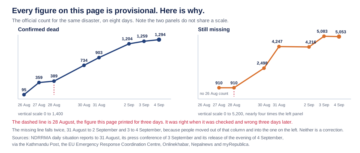
Treat every number on this page as the last one we could check. This page said 389 dead and 910 missing for three days, and it was the official count when it was written. Here is what happened to it while it sat there.

Two line charts showing the official dead and missing counts rising between 26 August and 4 September 2026
Why nothing on this page is called final. This is the official count for one disaster on eight days, and the dashed line is the figure this page itself printed for three of them.Scroll the diagram sideways to read it, or open the count on eight days at full size.Imperial College of Engineering, from NDRRMA daily reports.
What the count on eight days says, in words

Two line charts side by side, and they deliberately do not share a scale. The left panel is confirmed dead on a vertical scale of 0 to 1,400. The right panel is still missing on a scale of 0 to 5,200, nearly four times the left one. On a single axis the dead would flatten to nothing against 5,053 and the figure would misreport its own subject.

Confirmed dead, by date: 26 August, 95. 27 August, 359. 28 August, 389. 30 August, 734. 31 August, 903. 2 September, 1,204. 3 September, 1,259. 4 September, 1,294.

Still missing, by date: no count was published on 26 August. 27 August, 910. 28 August, 910. 30 August, 2,498. 31 August, 4,247. 2 September, 4,216. 3 September, 5,083. 4 September, 5,053.

The missing line falls twice, between 31 August and 2 September and again between 3 and 4 September. Neither is a correction: people moved out of the missing column and into the dead one, which is why the left panel climbs across the same days.

The dashed line marks 28 August, which is the figure this page printed for three days. It was right when it was checked and wrong three days later.

Nepal Police is not plotted. It published 1,290 on 4 September and 1,342 on 5 September, both above the authority this chart follows, on a basis that counts 532 partial remains among them. One series, one authority.

Sources: NDRRMA daily situation reports to 31 August, its press conference of 3 September and its release of the evening of 4 September, via the Kathmandu Post, the EU Emergency Response Coordination Centre, Onlinekhabar, Nepalnews and myRepublica, and for 26 August the Kathmandu Post rolling update.

In NDRRMA’s report of 21 September 2026, the last to break the total down, 636 of the missing were foreign nationals, 164 were Nepalis travelling with those visitors and 83 were serving security personnel: 45 Nepali Army, 25 Nepal Police, 13 Armed Police Force. Those are that day’s numbers against a total that has since moved. The largest single group is the 933 people who were at work on the hydropower projects, and they have their own post below.

Figures from National Disaster Risk Reduction and Management Authority, 8 October 2026

Aerial view of a debris fan of grey silt and boulders stopping at the edge of a cluster of houses

Where it killed people, and where it took them

The flood · 9 districtsThe dead and the missing are not in the same places, and the difference is the reason this reaches Chitwan.

The deaths and the missing are not in the same places, and if you are reading this from Chitwan or Nawalparasi that difference is the reason this is your disaster too. The water started at the Nepal–China border and it was still killing people 240 kilometres later, across the Indian border. Upstream, in Rasuwa and Nuwakot, it mostly did not leave bodies to recover.

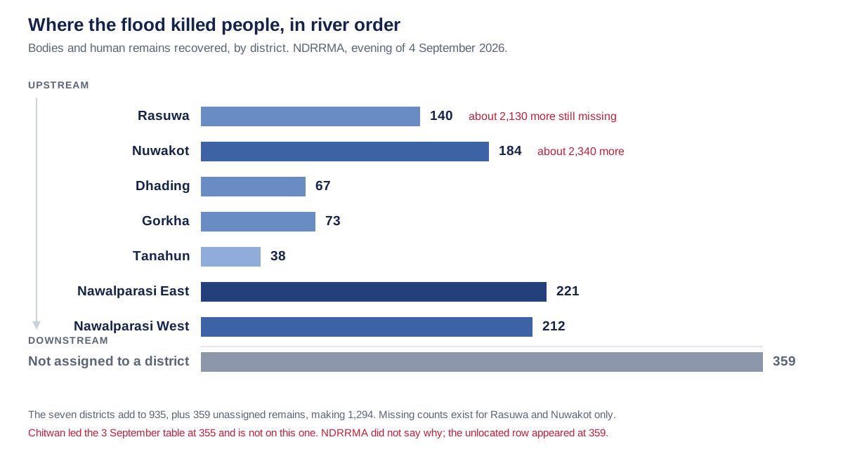
Bar chart of deaths by district in river order, Chitwan longest, and a small grey bar for deaths in Kathmandu hospitals
Read it top to bottom and you are travelling downstream. The two districts nearest the source hold most of the missing, and Chitwan, far below them, holds the most recovered dead. The grey bar is not a place.Scroll the diagram sideways to read it, or open deaths by district at full size.Imperial College of Engineering, from the NDRRMA district table of 21 September.
What deaths by district says, in words

Bodies and human remains recovered by district, from NDRRMA Situation Report #20 of 21 September 2026. The rows run in river order rather than by size, so reading top to bottom is travelling downstream from the Nepal to China border towards the Indian one.

Rasuwa, 236 dead and 3,513 more still missing on 21 September. Nuwakot, 203 dead and 1,708 more missing. Dhading, 72. Gorkha, 79. Tanahun, 38. Chitwan, 367, the longest bar. Nawalparasi East, 232. Nawalparasi West, 222.

A final bar, drawn in grey and set apart because it is not a place, carries 2 people who died in hospital in Kathmandu during treatment.

The nine rows add to 1,451, which was the whole toll in that report. The toll has moved on since: it is 1,455 on NDRRMA's briefing of 30 September, and no newer district table has been published. Nepal Police's table of 29 September prints Nuwakot as 24, almost certainly 204, and could not be read at source.

Chitwan is the largest entry and was missing from the 4 September table. It is back because NDRRMA publishes it again, in a table that adds to its own toll.

The shape is the argument. The two districts nearest the source hold 439 of the recovered dead and 5,221 of the people then counted as missing, because upstream the water did not leave bodies to recover. Most of the recovered dead, 821 of 1,451, are downstream in Chitwan and the two Nawalparasis, 150 kilometres and more from where the water started.

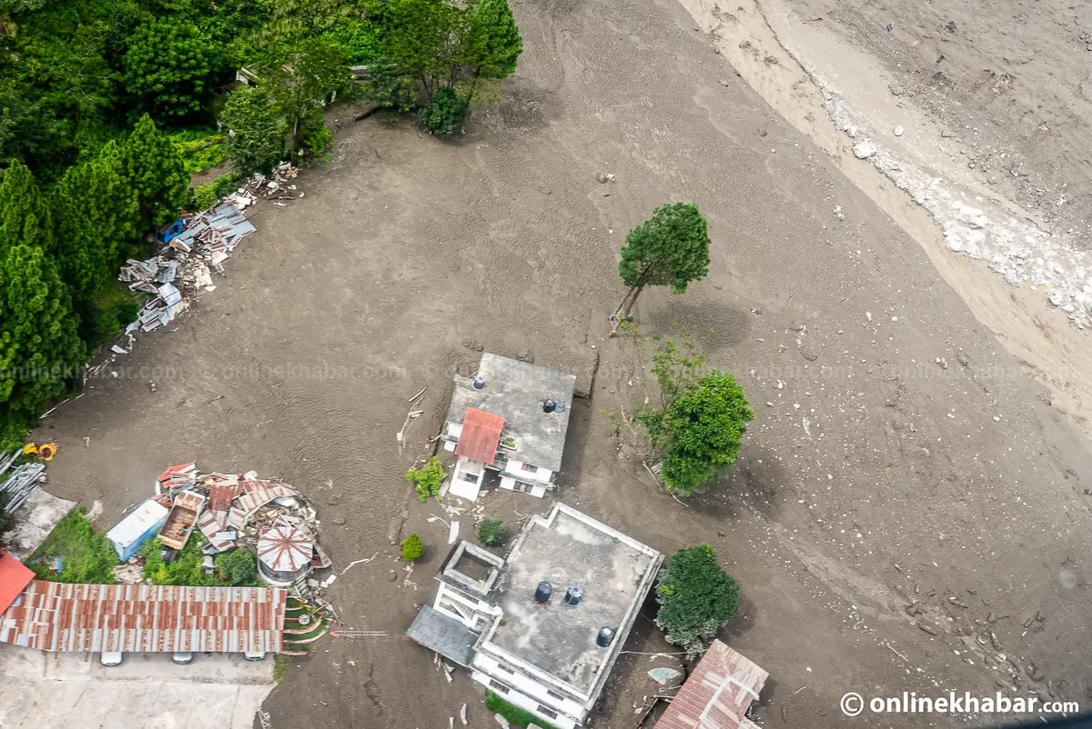
Aerial view of a debris fan of grey silt and boulders stopping at the edge of a cluster of houses
Where it stopped. Everything grey in this frame arrived on one morning, and the line it stopped at is the only reason the houses above it are standing.Kamal Prasai and Dinesh Gautam, Onlinekhabar.

The line that debris stopped at is the only thing separating the houses above it from the ones that are not there any more, and it was decided by the shape of the ground rather than by anything anybody did.

Rasuwa and Nuwakot are the districts the flood destroyed: the settlements, the roads and the bridges went, and between them those two hold 5,221 of the missing on 21 September 2026. The most deaths in the table are in Chitwan and Rasuwa. NDRRMA’s table of 21 September 2026 has 9 rows, eight districts and the people who died during treatment in Kathmandu, and they add to 1,451, 4 short of the 1,455 we print, because the toll has risen since that report and no newer table has been published. The chart above is that table. Chitwan, absent from the table of 4 September, is back as the longest bar. The government has declared 3 days of national mourning, has declared the affected local levels a disaster zone for 3 months, and has ordered treatment free at government hospitals for anyone injured in this flood.

We asked whether this loss was preventable, and put the question to two AI research agents arguing opposite sides. Their briefs, rebuttals and the points they agreed on are in our report on the 2026 Bhotekoshi flood, with sources, for anyone studying or teaching it.

Figures from National Disaster Risk Reduction and Management Authority, 8 October 2026

Aerial view of a river gorge stripped back to bare rock and grey debris with a pipeline section visible

How it actually happened

Engineering · the mechanismA bedrock failure, a debris dam, and the wall nobody had designed and nobody was watching.

In short: A bedrock and glacier mass of 100 to 200 million cubic metres failed on the north face of Langtang Lirung, on the Nepali side of the border and about 20 km north-east of the Rasuwagadhi crossing, at 08:37 on 26 August and became a debris flow down the Bhote Koshi and Trishuli. It was not a monsoon flood, a glacial lake outburst, or an earthquake. Read the full analysis in our Rasuwa flood report.

This was not a monsoon flood and it was not an earthquake, and both of those are still being repeated. What happened was a bedrock failure high on the ridge, about 20 kilometres above the border, which took the glacier sitting on top of it down as well. A face roughly 600 metres across fell 1,200 metres into the Lhende Khola. The United States Geological Survey first read the shock as a magnitude 4.4 earthquake and later corrected it: the magnitude 5.2 signal was made by the collapse, not the other way round.

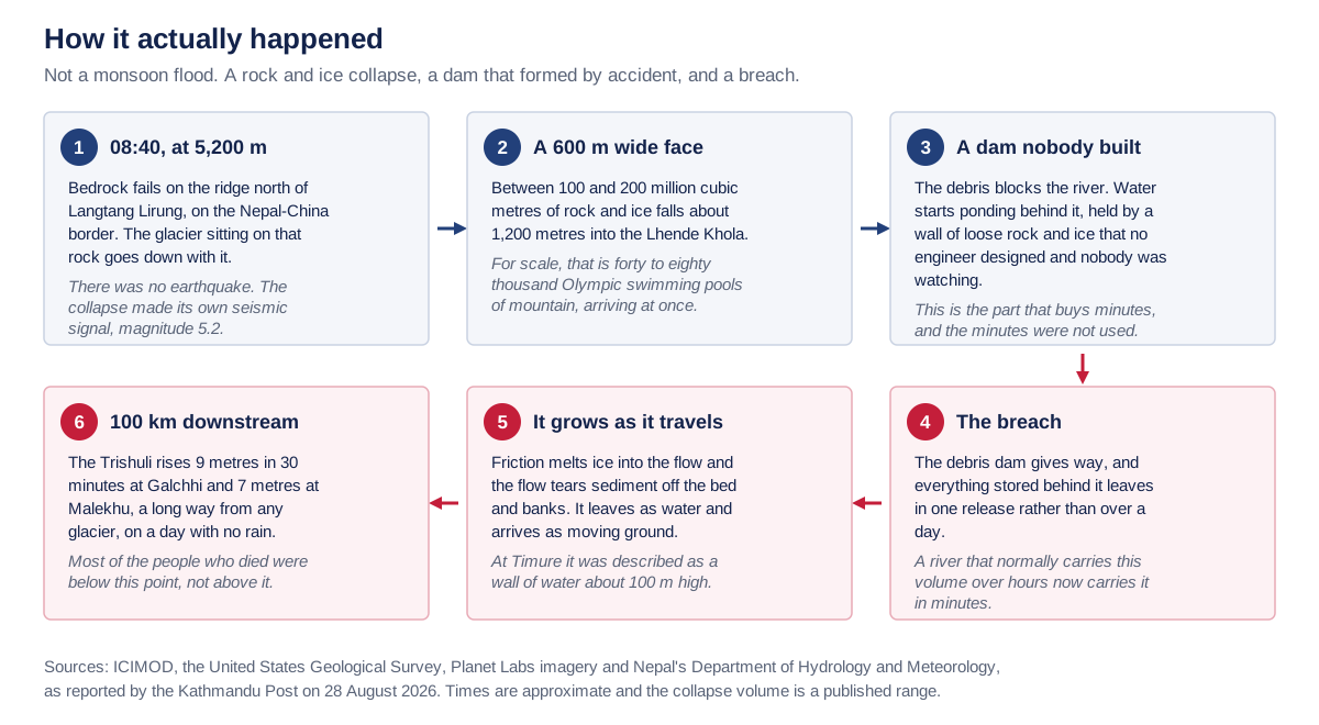
Six-step diagram of the flood: bedrock failure, avalanche, debris dam, breach, growth in transit, downstream surge
The mechanism, in order. Almost every account of this flood gives the outcome and skips this, which is how the earthquake version got loose.Scroll the diagram sideways to read it, or open how the flood happened at full size.Imperial College of Engineering, from ICIMOD, USGS and Kathmandu Post reporting.
What how the flood happened says, in words

Six steps, in the order they happened. One: at about 08:40, at 5,200 metres, bedrock fails on the ridge north of Langtang Lirung on the Nepal to China border, and the glacier sitting on that rock goes down with it. There was no earthquake. The collapse made its own seismic signal, magnitude 5.2.

Two: a face about 600 metres wide, between 100 and 200 million cubic metres of rock and ice, falls about 1,200 metres into the Lhende Khola. Three: the debris blocks the river, and water ponds behind a wall of loose rock and ice that no engineer designed and nobody was watching. That is the part that buys minutes, and the minutes were not used.

Four: the debris dam gives way and everything behind it leaves in one release rather than over a day. Five: friction melts ice into the flow and the flow tears sediment off the bed and the banks, so it leaves as water and arrives as moving ground. At Timure it was described as a wall of water about 100 metres high.

Six: about 100 kilometres downstream the Trishuli rises 9 metres in 30 minutes at Galchhi and 7 metres at Malekhu, a long way from any glacier, on a day with no rain. Most of the people who died were below this point, not above it.

Sources: ICIMOD, the United States Geological Survey, Planet Labs imagery and Nepal’s Department of Hydrology and Meteorology, as reported by the Kathmandu Post on 28 August 2026. Times are approximate and the collapse volume is a published range.

The volume is the part that is hard to hold in your head. Between 100 and 200 million cubic metres of rock and ice came off the mountain at once. What made it lethal, though, was not the volume but the sequence: the debris dammed the river, water ponded behind a wall nobody had designed and nobody was watching, and then that wall failed. A river that would normally carry that water over a day carried it in minutes.

A steep narrow gorge with near-vertical rock walls scoured pale by the passing flood
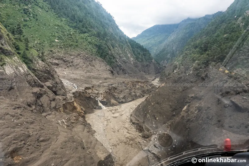
A confined gorge is why it moved so fast. The same volume through a narrower section has to go quicker and higher, and the pale band is how high.Kamal Prasai and Dinesh Gautam, Onlinekhabar.

It also arrived bigger than it left. Friction melted ice into the flow, and the flow tore sediment off the bed and the banks as it went, so what started as water reached the settlements as moving ground. At Timure it was described as a wall of water about 100 metres high. That is why the damage does not look like flooding.

Aerial view of a river gorge stripped back to bare rock and grey debris with a pipeline section visible
Stripped to the rock. This is what the reports mean by entrainment: the flow did not just pass through, it took the valley floor with it.Kamal Prasai and Dinesh Gautam, Onlinekhabar.
Aerial close view of concrete buildings standing in a flat grey plain of silt with only roofs and upper walls clear
The buildings did not fall down. The ground came up around them, which is why the recovery is being done with excavators rather than by searching rubble.Kamal Prasai and Dinesh Gautam, Onlinekhabar.

The buildings in that frame did not fall down. The ground came up around them, which is why the recovery is being done with excavators rather than by searching rubble, and why the missing outnumber the dead by about 3.6 to one.

Figures from National Disaster Risk Reduction and Management Authority, 8 October 2026

Aerial view of a Rasuwa valley with houses and terraced fields beside a river channel run wide and brown

The same valleys, two weeks apart

Satellite and ground · 6 framesA photograph shows you one bend of the river. These show you all 72 kilometres.

A photograph shows you one bend of the river. These show you all 72 kilometres of it. The first pair is the same frame a fortnight apart, so the brown is the only thing that changed.

Aerial view of a Rasuwa valley with houses and terraced fields beside a river channel run wide and brown
The reach on the afternoon of 26 August. The brown is not the river bank, it is where the river now is.Kamal Prasai and Dinesh Gautam, Onlinekhabar.
Aerial view of an entire valley floor filled bank to bank with grey flood debris between green hillsides
Bank to bank. The green line on either side is where the valley floor used to start.Kamal Prasai and Dinesh Gautam, Onlinekhabar.
Satellite view of the Langtang and Bhote Koshi valleys two weeks before the flood, green and unbroken
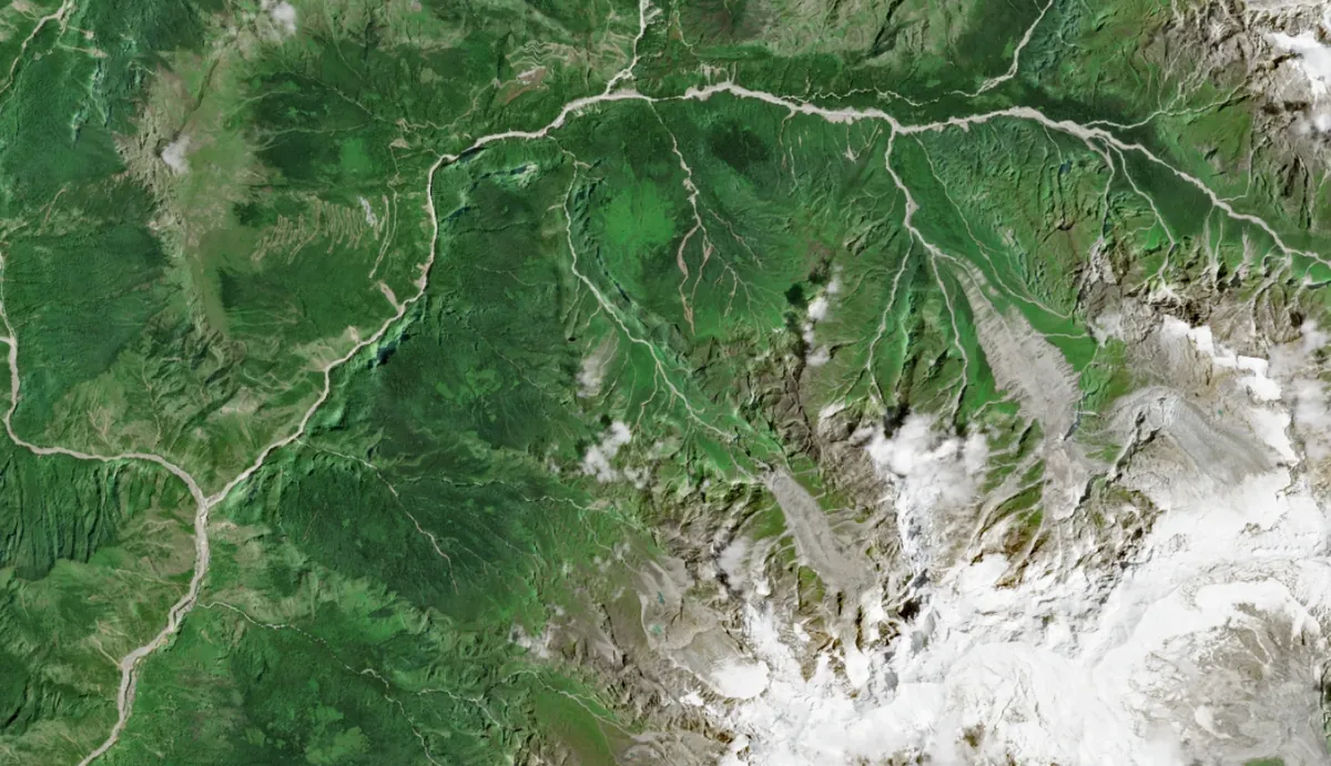
The same valleys on 12 August, two weeks before. The rivers are the thin pale threads.Contains modified Copernicus Sentinel data 2026.
Satellite view of the same valleys on the day of the flood, a wide brown scour running down the river
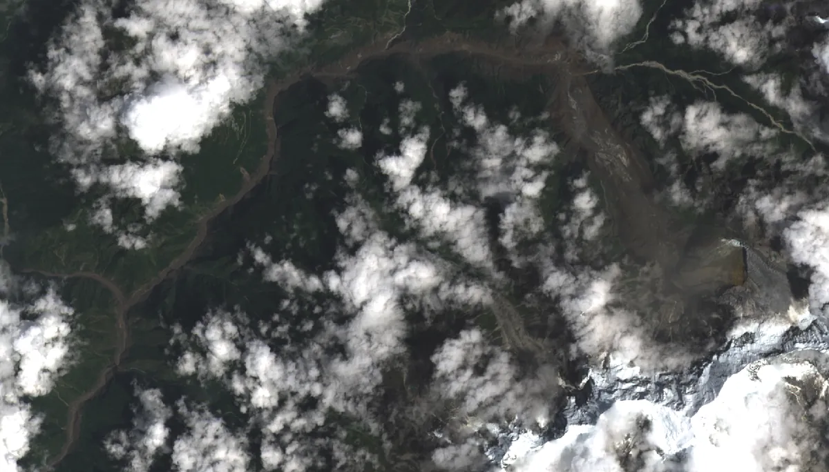
The same frame on 26 August, hours after. The brown is the river, and it is that wide for 72 kilometres.Landsat 9, USGS.
Before and after satellite pair of Betrawati and Gerkhu, showing the river channel widened by flood deposits
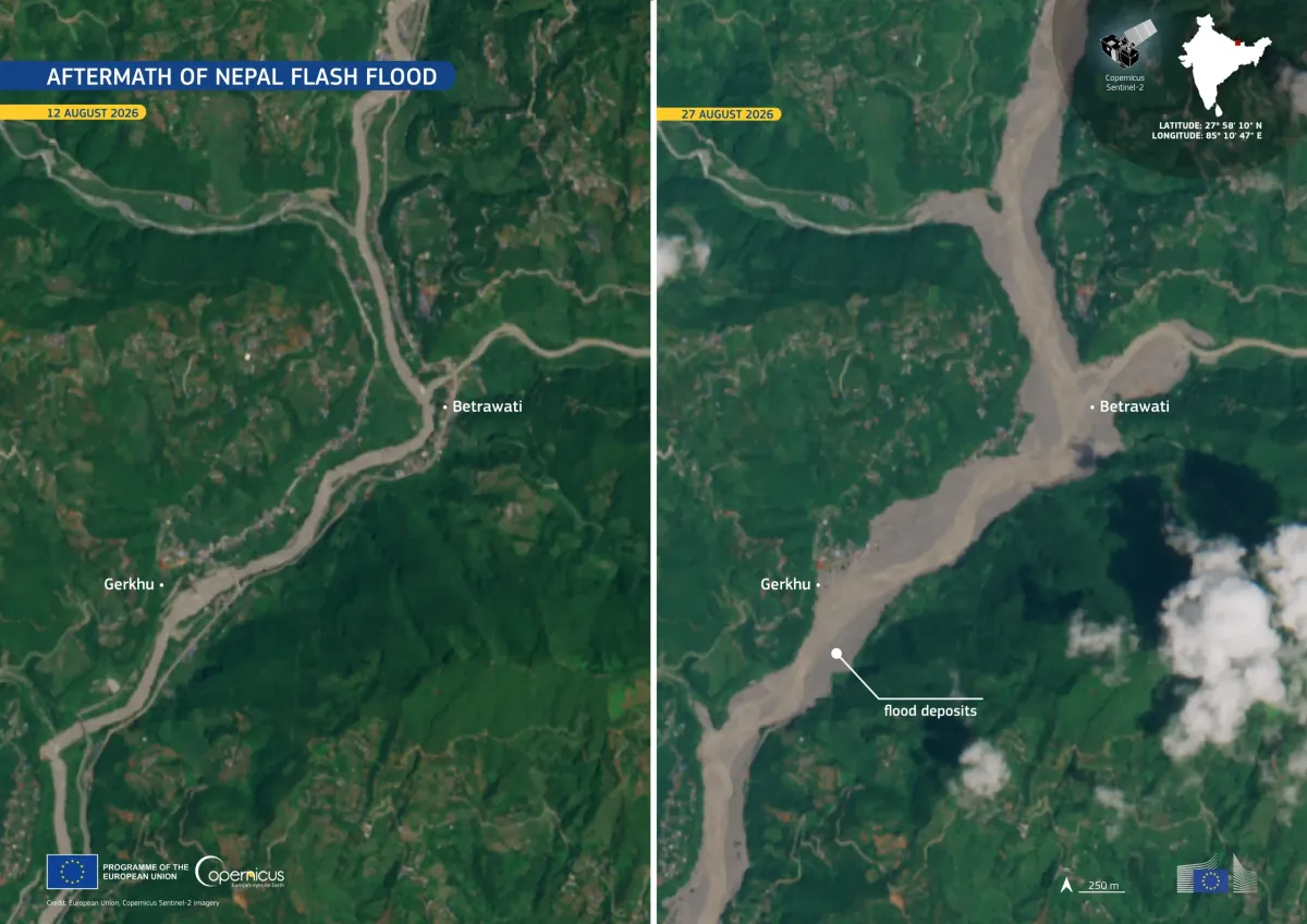
Betrawati and Gerkhu, on the Trishuli in Nuwakot, on 12 and 27 August. The river is several times its own width and the pale ground beside it is new.Nuwakot is one of the two districts that hold most of the missing: NDRRMA’s report of 21 September puts 1,708 of them there.European Union, Copernicus Sentinel-2.
Before and after satellite pair of Gyirong border port, buildings and a bridge replaced by grey debris
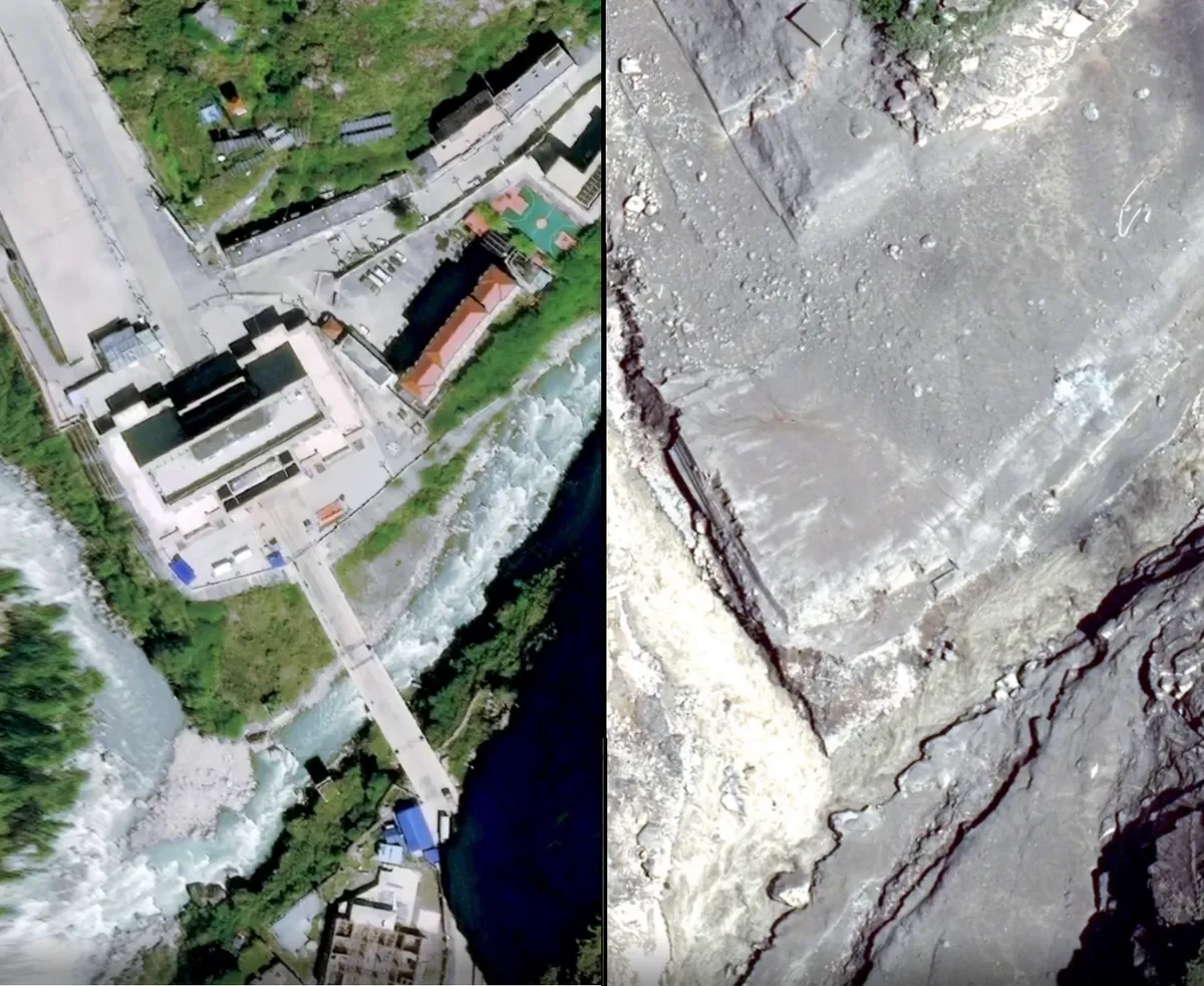
Gyirong port, the Chinese side of the Rasuwagadhi crossing, before and after. The buildings, the yard and the bridge in the left frame are under the grey in the right one.This is the far bank, not Nepal. It is here because it is the only freely licensed image of a built settlement on this river taken before and after.Wikimedia Commons, CC0.

If you want to see the ground rather than the satellite, these are the published galleries. They open on the publisher’s own site, which is where those photographs are licensed to be.

Figures from National Disaster Risk Reduction and Management Authority, 8 October 2026

Why nobody was warned

Engineering · the warning chainThe collapse was detected within seconds. Nothing turned that reading into a warning.

In short: The collapse registered on seismometers within seconds, but the warning travelled by telephone and took about 51 minutes, longer than the 35 minutes the flood took to reach Nepal. Read the full analysis in our Rasuwa flood report.

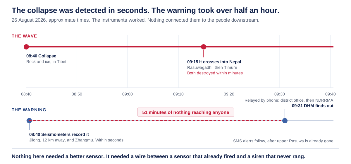
The collapse was detected. A seismometer at Jilong, 12 kilometres away, recorded it within seconds, and so did the station at Zhangmu. Nothing turned that into a warning. Nepal’s Department of Hydrology and Meteorology found out about the flood roughly 16 minutes after it had already crossed the border, by telephone, relayed from the Rasuwa district office through the national disaster authority. The SMS alerts went out after that, by which time upper Rasuwa was gone.

Two-track timeline showing the wave travelling while the warning is relayed by telephone over 51 minutes
The hour that decided the toll. The instruments fired in seconds; the message took fifty-one minutes and travelled by telephone.Scroll the diagram sideways to read it, or open the warning timeline at full size.Imperial College of Engineering, from ICIMOD and DHM reporting.
What the warning timeline says, in words

Two tracks across one hour on 26 August 2026, from 08:40 to 09:40. Times are approximate, because the sources give them to the nearest few minutes.

The wave: at 08:40 the rock and ice collapse happens, on the north face of Langtang Lirung on the Nepali side of the border. At about 09:15 it crosses into Nepal at Rasuwagadhi, then Timure, and both are destroyed within minutes.

The warning: at 08:40, within seconds, seismometers at Jilong 12 kilometres away and at Zhangmu record it. Then 51 minutes of nothing reaching anyone. At about 09:31 the Department of Hydrology and Meteorology finds out, relayed by telephone from the district office and then NDRRMA. The SMS alerts follow that, after upper Rasuwa is already gone.

The point of the figure: nothing here needed a better sensor. It needed a wire between a sensor that already fired and a siren that never rang.

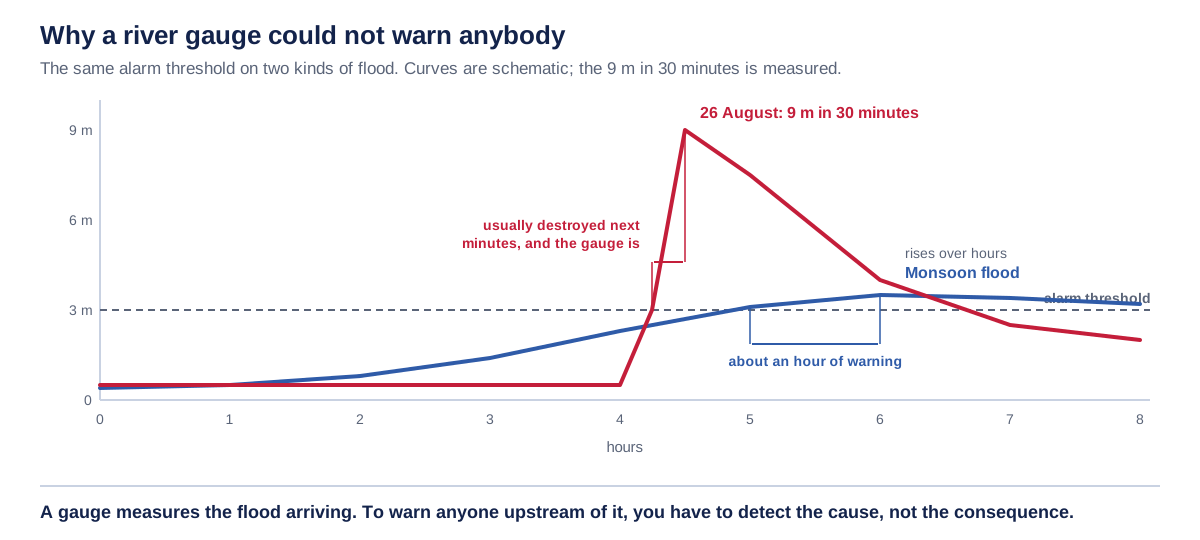
The obvious question is why the river gauges did not catch it, and the answer is that they are the wrong instrument for this. A gauge measures a flood that has already arrived. On a monsoon flood that is enough, because the level climbs for hours and the crossing of a threshold leaves time to act. On this, the level crossed every threshold and the peak arrived in the same few minutes, and several of the gauges were destroyed immediately afterwards.

Two hydrographs on one axis: a monsoon flood rising over hours against a glacial surge rising in minutes
Why a river gauge could not help. The same alarm threshold gives an hour of warning on the blue curve and none on the red one.Curves are schematic. The 9 metres in 30 minutes at Galchhi is measured.Scroll the diagram sideways to read it, or open the two hydrographs at full size.Imperial College of Engineering.
What the two hydrographs says, in words

Two river-level curves on one axis, hours across the bottom from 0 to 8 and metres up the side from 0 to 9, with a horizontal alarm threshold drawn across both.

The blue curve is a monsoon flood. It climbs gradually across several hours, crosses the alarm threshold, and only peaks well after it. The gap between the crossing and the peak is about an hour of warning, and that gap is what makes a gauge useful.

The red curve is 26 August. It sits flat, then goes almost vertical: 9 metres in 30 minutes. It crosses the alarm threshold and reaches its peak inside the same few minutes, so the threshold buys nothing, and the gauge is usually destroyed next.

The curves are schematic. What is measured is the 9 metre rise in 30 minutes at Galchhi and 7 metres at Malekhu, and that Nepal’s Department of Hydrology and Meteorology recorded no heavy rainfall in Rasuwa on either day.

A gauge measures the flood arriving. To warn anyone upstream of it, you have to detect the cause, not the consequence.

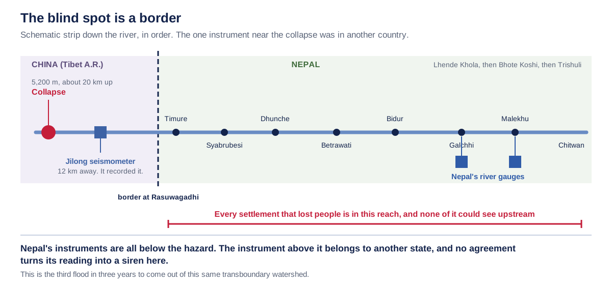
Underneath both of those is a problem Nepali equipment alone does not fix. The collapse was on the Nepali side of the border, but at the head of a valley the two countries share. Every instrument Nepal owns on this river sits below the thing that needed detecting, and the one instrument that recorded it, a seismometer at Jilong in China, belongs to a state with no agreement in place to turn its readings into an alarm here. This is the third flood in three years to come down this same transboundary watershed.

Schematic strip of the river showing the collapse and the nearest seismometer in China and Nepal gauges downstream
The structural problem. Every instrument Nepal owns is below the hazard, and the one instrument above it belongs to another state.Scroll the diagram sideways to read it, or open the blind spot at the border at full size.Imperial College of Engineering, from ICIMOD.
What the blind spot at the border says, in words

A schematic strip down the river, in correct order, with the border at Rasuwagadhi marked across it. At the head of the strip is the border valley, where the Lhende Khola marks the border; below the Rasuwagadhi crossing it is Nepal all the way down. The watercourse is the Lhende Khola, then the Bhote Koshi, then the Trishuli.

At the head of the valley: the collapse, on the Nepali side, at 5,200 metres, about 20 kilometres up, and the Jilong seismometer in China, 12 kilometres away, which recorded it.

On the Nepali side, in order down the river: Timure, Syabrubesi, Dhunche, Betrawati, Bidur, Galchhi, Malekhu, Chitwan. Nepal’s river gauges sit at and below Betrawati. Every settlement that lost people is in this reach, and none of it could see upstream.

Only the 12 kilometre and 20 kilometre figures are stated, because those are the two that are published. The distances along the strip are schematic and only their order is meant.

Nepal’s instruments are all below the hazard. The one instrument that recorded it belongs to another state, and no agreement turns its reading into a siren here. This is the third flood in three years to come out of this same transboundary watershed.

Figures from National Disaster Risk Reduction and Management Authority, 8 October 2026

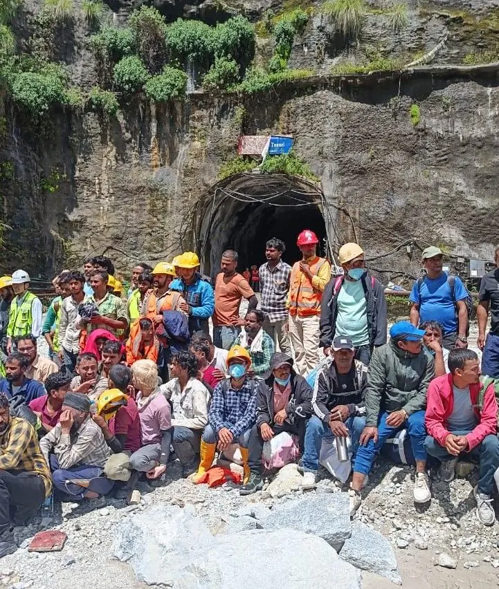
Dozens of hydropower workers in hard hats sitting and standing outside a tunnel mouth after being rescued

The people inside the power stations

The flood · 933 missing from 11 projectsThe wave went through working power stations in the middle of a Wednesday shift. This is our own profession.

In short: Run-of-river hydropower puts intakes, powerhouses, camps and shifts on the valley floor, so the flood went through working power stations. Hundreds of hydropower workers are among the missing. Read the full analysis in our Rasuwa flood report.

The Trishuli is a hydropower river, so the wave went through working power stations in the middle of a Wednesday shift. 933 people who were at work on those projects are missing, across 11 projects, and 361 have been rescued or walked out on their own. They were civil, electrical and electronics engineers, technicians and construction crews. This college’s own profession, and most of them will have trained in colleges like this one. We are an engineering college and we are not going to write about this flood without saying so.

That figure was 133 on this page from 28 to 31 August, when only four projects had reported. That count is about one in 6 of everyone now listed as missing in the whole disaster. The two bodies counting it do not quite agree, which is normal this early and is better said than smoothed over: the National Disaster Risk Reduction and Management Authority says 933 and the Independent Power Producers’ Association says 934.

Most of them are underground. The Nepali Army has put 19 tunnels in priority order, and this is what a rescue at one of them is actually trying to do. On 30 September 2026 the government moved its effort from rescue to search and recovery, because the chance of finding survivors has faded, and searching was still going on at two tunnel sites.

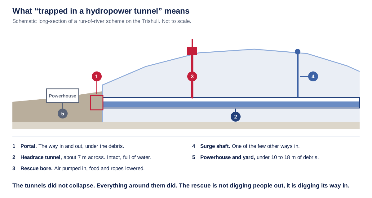
Schematic section of a run-of-river hydropower scheme showing the buried portal, flooded headrace tunnel and rescue bore
What the reports mean by a tunnel. The bore itself held; the portal, the powerhouse and the yard are under the debris, so the only ways in are drilled from above.Scroll the diagram sideways to read it, or open the tunnel long-section at full size.Imperial College of Engineering. Schematic, not to scale.
What the tunnel long-section says, in words

A schematic long-section of a run-of-river scheme on the Trishuli, cut through the mountain the tunnel is bored through. Not to scale, and not a survey of any one project.

Five numbered features. One, the portal: the way in and out, and it is under the debris. Two, the headrace tunnel, about 7 metres across, intact and full of water, running off towards the intake upstream. Three, the rescue bore, drilled from the surface, with air pumped in and food and ropes lowered through it. Four, the surge shaft, one of the few other ways in. Five, the powerhouse and yard, under 10 to 18 metres of debris.

The sentence the drawing exists for: the tunnels did not collapse, everything around them did, so the rescue is not digging people out, it is digging its way in.

At Trishuli 3A the Nepali Army found the tunnel crown on 30 August, drilled through it, and found water standing high inside a bore about seven metres across. Ropes went down, rescuers called, and nothing answered. At Upper Trishuli-1, 350 people were brought out and more than 100 are still believed to be inside.

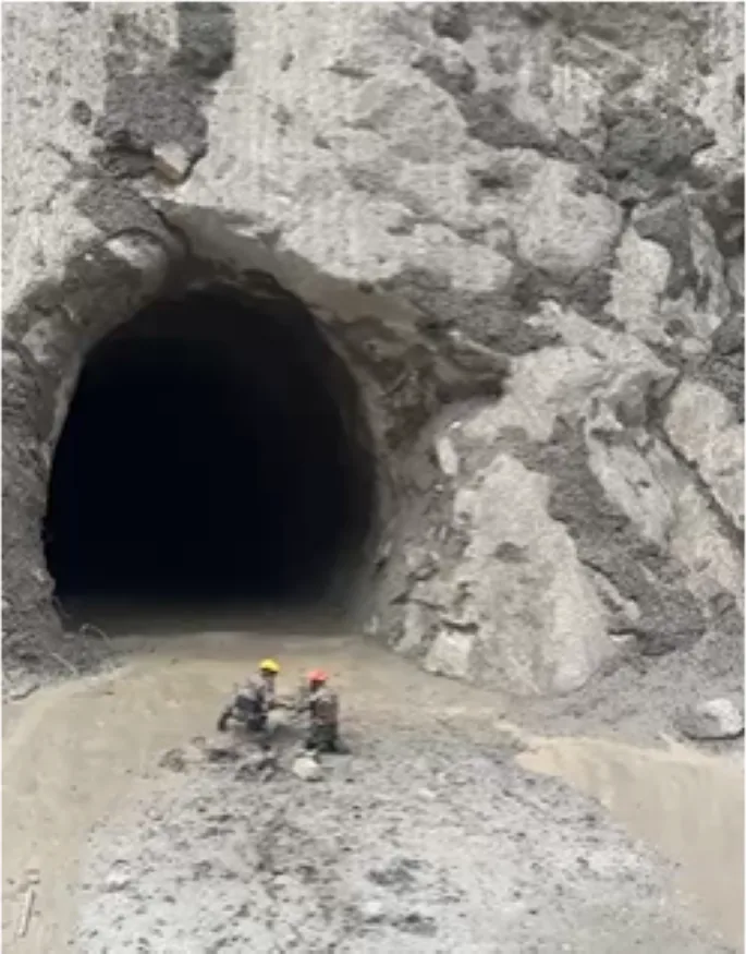
Two rescuers in hard hats kneeling at the mouth of a hydropower tunnel surrounded by grey flood silt
The scale a rescue works at. Two rescuers at the tunnel mouth, and the grey covering everything is what the river left.Nepali Army, via The Rising Nepal.

It does work. This is the tunnel at Upper Trishuli-1 after the Army brought 350 people out of it alive.

Dozens of hydropower workers in hard hats sitting and standing outside a tunnel mouth after being rescued
The men who came out. 350 people were brought alive from the tunnel at Upper Trishuli-1 by an Army team from the Trishuli tactical headquarters, and more than 100 are still believed to be inside it.Nepali Army, via The Rising Nepal.
  • Upper Trishuli-1

    350 people have been brought out of the tunnel at this 216 MW project in Rasuwa. More than 100 are still believed to be inside it.

  • Trishuli 3A

    The Army found the tunnel crown on 30 August and drilled through it. Water is standing high inside a bore about seven metres across. Ropes went down, rescuers called, and nothing answered. The Army puts at least 35 people inside; Nepal Police puts it near 200.

  • Langtang Khola

    Around 60 workers were inside a tunnel. The powerhouse was swept away days before the project was due to start generating.

  • Rasuwagadhi and Chilime

    Staff are unaccounted for after the plants and the customs yard beside them were destroyed. Over 300 vehicles went with them.

431 megawatts left the national grid with them, and another 470 megawatts of projects still being built were damaged, so expect power cuts for a long time. If you are a family member of someone who was on one of these sites, the project operators are reporting to the district authorities, and the missing-person route above is the same one everybody else is using. Use it as well, not instead.

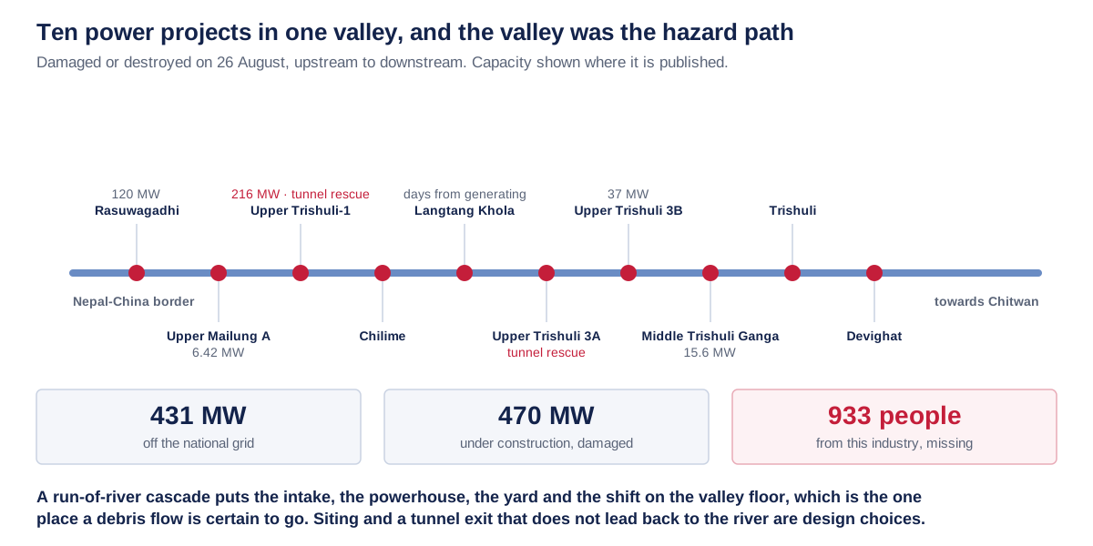
There is a design question inside that number, and it is a question rather than an accusation. The Trishuli carries 10 projects that were damaged or destroyed in one morning. A run-of-river scheme puts its intake, its powerhouse, its yard and its shift on the valley floor, because that is where the water is. The valley floor is also the one place a debris flow is guaranteed to go.

Diagram of ten hydropower projects along the Trishuli with capacities, all damaged or destroyed on 26 August
Ten projects in one valley. A run-of-river cascade puts the assets and the shift on the valley floor, which is the one place a debris flow is certain to go.Scroll the diagram sideways to read it, or open ten power projects in one valley at full size.Imperial College of Engineering, from published project capacities.
What ten power projects in one valley says, in words

Ten hydropower projects strung down one corridor, drawn upstream to downstream from the Nepal to China border towards Chitwan, all damaged or destroyed on 26 August. Capacity is shown only where it is published.

Rasuwagadhi, 120 MW. Upper Trishuli-1, 216 MW, a tunnel rescue site. Upper Mailung A, 6.42 MW. Chilime. Langtang Khola, days from generating. Upper Trishuli 3A, a tunnel rescue site. Upper Trishuli 3B, 37 MW. Middle Trishuli Ganga, 15.6 MW. Trishuli. Devighat.

The totals along the bottom: 431 MW off the national grid, another 470 MW under construction and damaged, and 933 people from this one industry missing.

The design point, and it is a question rather than an accusation: a run-of-river cascade puts the intake, the powerhouse, the yard and the shift on the valley floor, which is the one place a debris flow is certain to go. Siting and a tunnel exit that does not lead back to the river are design choices.

Figures from National Disaster Risk Reduction and Management Authority, 8 October 2026

What would actually prevent this

Engineering · preventionNothing on this list stops a mountain coming down. All of it buys minutes for the people below.

In short: Nothing stops a mountain coming down, but an automatic trigger on a silent border gauge, a live data link with China, clear alerts and a second road would buy minutes and keep the capital connected. Read the full analysis in our Rasuwa flood report.

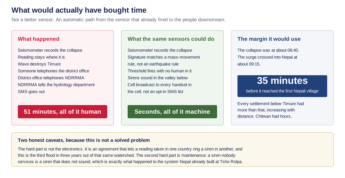
The honest starting point is that nothing on this list would have stopped the mountain coming down. The question is only ever how much of the 35 minutes between the collapse and the first Nepali village you can hand to the people living in it, and how much more you can hand to everyone further down.

Three-column comparison of the 51-minute human warning chain against an automated seismic trigger and its 35-minute margin
What would actually have bought time, and the two reasons it is harder than it looks. The margin was real: 35 minutes before the wave reached the first Nepali village.Scroll the diagram sideways to read it, or open what would have bought time at full size.Imperial College of Engineering.
What what would have bought time says, in words

Three columns. The first is what happened: a seismometer records the collapse, the reading stays where it is, the wave destroys Timure, someone telephones the district office, the district office telephones NDRRMA, NDRRMA tells the hydrology department, and an SMS goes out. Total, 51 minutes, all of it human.

The second is what the same sensors could do: a seismometer records the collapse, the signature is matched against a mass-movement rule rather than an earthquake rule, a threshold fires with no human in it, sirens sound in the valley below, and a cell broadcast reaches every handset in the cell rather than an opt-in SMS list. Total, seconds, all of it machine.

The third is the margin it would use. The collapse was at about 08:40 and the surge crossed into Nepal at about 09:15, so there were 35 minutes before it reached the first Nepali village. Every settlement below Timure had more than that, increasing with distance. Chitwan had hours.

Two honest caveats, because this is not a solved problem. The hard part is not the electronics; it is an agreement that lets a reading taken in one country ring a siren in another, and this is the third flood in three years out of that same watershed. The second hard part is maintenance: a siren nobody services is a siren that does not sound, which is exactly what happened to the system Nepal already built at Tsho Rolpa.

The first fix is not a better sensor. It is an automatic path from a sensor that already fired to a siren that never rang, and a cross-border agreement that lets a reading taken on one side of a line ring a bell on the other. The electronics for that are cheap and forty years old. The agreement is the hard part, and it is the part that has now failed three times in three years on this one river.

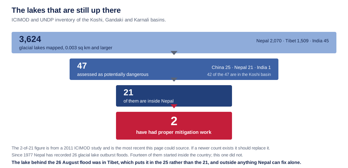
The second is the standing inventory. Nepal, Tibet and India between them hold 3,624 mapped glacial lakes. 47 of those are rated potentially dangerous, and 21 of those are inside Nepal. Two have had mitigation work done on them, on the most recent count we could source, which is a 2011 ICIMOD study. If a newer figure exists it should replace this one.

Funnel diagram from 3,624 mapped glacial lakes to 47 dangerous ones to the 2 in Nepal with mitigation work
The standing problem. Of the 21 lakes inside Nepal rated potentially dangerous, two have had mitigation work done on them.The 2-of-21 figure is from a 2011 ICIMOD study, the most recent this page could source.Scroll the diagram sideways to read it, or open the glacial lake inventory at full size.Imperial College of Engineering, from the ICIMOD and UNDP inventory.
What the glacial lake inventory says, in words

A funnel in four steps, from the ICIMOD and UNDP inventory of the Koshi, Gandaki and Karnali basins.

Step one: 3,624 glacial lakes mapped, of 0.003 square kilometres and larger. Nepal 2,070, Tibet 1,509, India 45.

Step two: 47 of those are assessed as potentially dangerous. China 25, Nepal 21, India 1. Forty-two of the 47 are in the Koshi basin.

Step three: 21 of the 47 are inside Nepal. Step four: 2 of those 21 have had proper mitigation work. That 2-of-21 is from a 2011 ICIMOD study and is the most recent this page could source; if a newer count exists it should replace it.

Since 1977 Nepal has recorded 26 glacial lake outburst floods, and 14 of them started inside the country. The 26 August flood was not an outburst at all: ICIMOD calls it an ice and rock avalanche that began on the Nepali side, with no lake behind it.

There was no lake behind this flood, which is worth saying plainly: ICIMOD calls it an ice and rock avalanche that began on the Nepali side, so a lake programme would not have reached it, and the 21 lakes inside Nepal are the ones Nepal can still act on. Since 1977 the country has recorded 26 outburst floods, and 14 of them started at home. Those are the ones a lake programme reaches.

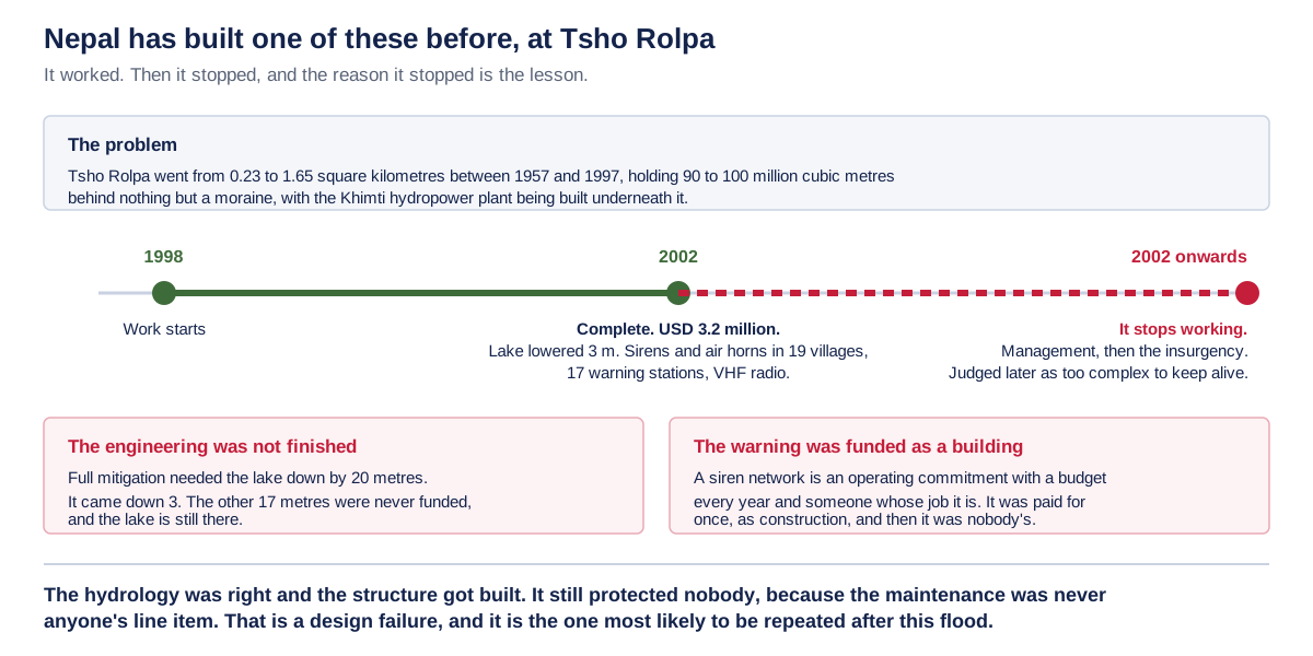
The last one is the uncomfortable one, and it is the reason this section exists on a college website rather than a ministry one. Nepal has already built exactly the system everyone is now calling for.

Timeline of the Tsho Rolpa lake lowering and warning system, built by 2002 and out of service from the same year
Nepal has built one of these before. The hydrology was right and the structure got built, and it still protected nobody.Scroll the diagram sideways to read it, or open the Tsho Rolpa lesson at full size.Imperial College of Engineering, from the published project record.
What the Tsho Rolpa lesson says, in words

The problem: Tsho Rolpa grew from 0.23 to 1.65 square kilometres between 1957 and 1997, holding 90 to 100 million cubic metres behind nothing but a moraine, with the Khimti hydropower plant being built underneath it.

A timeline in three marks. 1998: work starts. 2002: complete, at USD 3.2 million, with the lake lowered 3 metres and sirens and air horns in 19 villages fed by 17 warning stations on VHF radio. 2002 onwards: it stops working, through management and then the insurgency, and was judged later as too complex to keep alive.

Two findings sit under the timeline. The engineering was not finished: full mitigation needed the lake down by 20 metres and it came down 3, so the other 17 metres were never funded and the lake is still there. And the warning was funded as a building: a siren network is an operating commitment with a budget every year and someone whose job it is, and it was paid for once, as construction, and then it was nobody’s.

The hydrology was right and the structure got built. It still protected nobody, because the maintenance was never anyone’s line item. That is a design failure, and it is the one most likely to be repeated after this flood.

Tsho Rolpa was lowered 3 metres of the 20 its engineers said full mitigation needed, for US$3.2 million, with sirens and air horns in 19 villages fed by 17 warning stations. It was finished in 2002. It stopped working in 2002. The hydrology was right and the structure got built, and it still protected nobody, because a warning network is an operating commitment with a budget every year and a named person responsible, and it was paid for once as construction and then belonged to nobody.

That is the failure most likely to be repeated after this flood, while the money is available and the attention is on. If a student reading this ends up working on the reconstruction, it is the thing worth arguing about in the meeting.

Figures from National Disaster Risk Reduction and Management Authority, 8 October 2026

If you are our student or applicant

The college · deadlinesCall us before you worry about a deadline. The one we cannot move, and the two we can work around.

Call the college if this has reached your family. Whatever it is, a funeral, a missing relative, a house gone, a road you cannot cross, tell us before you worry about a deadline and we will work around it.

01-5091616

There were deadlines we could not move, and you should know how they fell. The second IOE merit list published on 30 August, 10:00 am, and admission from it ran to 2 September, 3:00 pm. The third list published 6 September, 10:00 am, and admission from it closed 8 September, 3:00 pm. Those hours were set centrally by the Institute of Engineering, not by us, and that was the end of the central schedule. If the roads cost you one of those windows, you are not finished: fourth and later lists run on each campus's own published timetable, and seats that fall vacant can be filled as late as 2 December. Ring us and we will tell you what your rank still reaches. The Prithvi Highway is the road most applicants from west of the Valley travel on. It reopened at Krishnabhir on 17 September, was blocked again by landslides on 26 September, reopened to all vehicles on 30 September, and was reported two-way on 1 October. On the evening of 9 October it subsided at Galaundi near Gajuri and shut again, and the Department of Roads ran it one way from the night of 10 October. The roads section above has where every route into the Valley stood on 11 October 2026.

You do not have to be standing at our counter to take the seat. Our online admission desk completes the whole thing from a phone. You sign in with the IOE roll number you already have, and it works on a slow connection. Bring your original documents to campus whenever the roads let you. If you would rather have a person do it with you, call the number above and we will walk through it on the phone.

If you are already studying here rather than applying, IOE has revised your Bhadra semester routine twice, on 31 August and again on 2 September. The regular BE and BAR papers are dated from 13 September, one year at a time over four days. How far your own papers moved depends on your year, and it is not the same number for anybody. We read all three routines against each other and published what moved, beside the road status above, at getting to the examination hall on the revised dates.

If the flood put you in hospital, in mourning, or out of your home, and you missed a paper because of it, Tribhuvan University's Registrar wrote on 3 September that you get a separate sitting on par with the regular exam, on certified documents. Applications went through your own campus or college by 15 September, and every campus had to have them at IOE's Examination Control Division by 17 September. Both deadlines have passed. On 23 September IOE published the timetable, notice 15539: five papers, 2 to 9 October, every one at 1:00 pm, at Pulchowk Campus. The earlier letters named the week of 24 to 30 September, and the sitting is not in that week. The five papers and what changed are on our notice board. If you filed and a paper is not among the five, call the number above and we will find out where it stands.


भावपूर्ण श्रद्धाञ्जलीEveryone at Imperial College of Engineering grieves with the families of Rasuwa and Nuwakot, and with everyone still waiting for news from that river. If this page is missing a number that would have helped you, tell us at [email protected] and we will check it and add it.